Aggregate Existing Features
The geometric_features.aggregation module contains functions used to
aggregate existing features to make new, larger ones. An example usage of these
aggregation functions is to create masks for regional averaging.
The function geometric_features.aggregation.get_aggregator_by_name()
can be used to get information about one of the aggregated features by one of
the following group names:
Antarctic Regions
Arctic Ocean Regions
Arctic Sea Ice Regions
Greenland Regions
Ocean Basins
Ice Shelves
Ocean Subbasins
ISMIP6 Regions
Transport Transects
This function returns the function that will aggregate the requested group, a prefix for the group (a modified version of the group name) and a date stamp that is updated each time the features in the group are changed. This way, mask files can be created from these features with filenames that include the date stamp. As long as the date stamp has not changed, these cached mask files can be reused.
Aggregating Ocean Features
Ocean Sub-basins
The function geometric_features.aggregation.ocean.subbasins()
aggregates oceanic regions to make the following ocean subbasins: North and
South Atlantic, North and South Pacific, Indian Basin, Arctic Basin, and
Southern Ocean Basin.
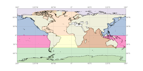
Ocean Basins
The function geometric_features.aggregation.ocean.basins() aggregates
oceanic regions to make the following ocean basins: Atlantic, Pacific, Indian,
Arctic, Southern Ocean, Mediterranean, Global Ocean, Global Ocean 65N to 65S,
Global Ocean 15S to 15N.
Meridional Overturning Circulation Basins
The function geometric_features.aggregation.ocean.moc() aggregates
basins for computing the MOC: Atlantic, IndoPacific, Pacific and Indian
Arctic Regions
The function geometric_features.aggregation.ocean.arctic() aggregates
regions of the Arcic (and subArctic): Baffin Bay, Baltic Sea, Barents Sea,
Beaufort Gyre, Beaufort Gyre Shelf, Canada Basin, Canadian Archipelago,
Central Arctic, Chukchi Sea, East Siberian Sea, Greenland Sea, Hudson Bay,
Irminger Sea, Kara Sea, Labrador Sea, Laptev Sea, North Sea, Norwegian Sea, and
Arctic Ocean - no Barents, Kara Seas.
Antarctic Regions
The function geometric_features.aggregation.ocean.antarctic() aggregates
regions of the Antarctic: Southern Ocean, Southern Ocean 60S,
Eastern Weddell Sea Shelf, Eastern Weddell Sea Deep, Western Weddell Sea Shelf,
Western Weddell Sea Deep, Weddell Sea Shelf, Weddell Sea Deep,
Bellingshausen Sea Shelf, Bellingshausen Sea Deep, Amundsen Sea Shelf,
Amundsen Sea Deep, Eastern Ross Sea Shelf, Eastern Ross Sea Deep,
Western Ross Sea Shelf, Western Ross Sea Deep, East Antarctic Seas Shelf,
East Antarctic Seas Deep.
Greenland Regions
The function geometric_features.aggregation.ocean.greenland()
aggregates regions of the continental shelves around Greenland based on the
ISMIP6 regions: ISMIP6 Greenland Central East Shelf,
ISMIP6 Greenland Central West Shelf, ISMIP6 Greenland North East Shelf,
ISMIP6 Greenland North Shelf, ISMIP6 Greenland North West Shelf,
ISMIP6 Greenland South East Shelf, ISMIP6 Greenland South West Shelf.
Ice-shelf Regions
The function geometric_features.aggregation.ocean.ice_shelves()
aggregates ice shelves and ice-shelf regions. There are 106 regions, so they
won’t all be listed. See the resulting feature collection or the code itself
for the full list.
Transport Transects
The function geometric_features.aggregation.ocean.transport()
aggregates transport transects: Africa-Ant, Agulhas, Antilles Inflow,
Barents Sea Opening, Bering Strait, Davis Strait, Drake Passage,
Florida-Bahamas, Florida-Cuba, Fram Strait”, Indonesian Throughflow,
Lancaster Sound, Mona Passage”, Mozambique Channel, Nares Strait, Tasmania-Ant
Windward Passage.
Aggregating Sea-ice Features
Arctic Regions
The function geometric_features.aggregation.seaice.arctic() aggregates
regions of the Arctic as defined by the
National Snow and Ice Data Center (NSIDC) that are
relevant for sea ice: Baffin Bay NSIDC, Barents Sea, Beaufort Sea NSIDC,
Canadian Archipelago NSIDC, Central Arctic NSIDC, Chukchi Sea NSIDC,
East Siberian Sea NSIDC, Hudson Bay NSIDC, Kara Sea, Laptev Sea NSIDC.